A fully robotic total station with automated target recognition is typically the first piece of equipment deployed on a deep excavation site in Glendale. The instrument tracks prism arrays mounted on soldier piles, tieback anchor heads, and neighboring building facades, streaming millimeter-level displacement data to a cloud dashboard every 15 minutes. Given the city’s location along the Verdugo Fault zone and the transition from dense alluvium to weathered granitic bedrock, the monitoring array must be capable of separating settlement caused by dewatering—common in the San Fernando Valley basin—from lateral movement triggered by shoring deflection. When the excavation crosses the contact between recent Holocene fan deposits and older Pleistocene terrace materials, we often recommend supplementing surface readings with in-place inclinometer strings installed behind the shoring wall to capture the complete deformation profile. This layered approach aligns with OSHA Subpart P requirements and the Glendale Building & Safety division’s threshold criteria for vibration monitoring near structures built before the 1971 Sylmar earthquake retrofit ordinances.
Separating settlement caused by dewatering from lateral wall deflection requires at least two independent monitoring datums—surface prisms alone cannot resolve the ambiguity.
Scope of work in Glendale California
Risks and considerations in Glendale California
The most common and costly mistake general contractors make in Glendale is assuming that a pre-construction condition survey of adjacent properties eliminates liability for excavation-induced damage. A photographic survey without continuous instrumental monitoring provides no defense when a neighboring property owner files a claim under California Civil Code §832 for lateral support. We have observed multiple projects where a tieback anchor drilled into saturated alluvium created a temporary hydraulic connection between two aquifers, triggering settlement 40 feet beyond the shoring line—movement that would have been detected within hours had automated settlement plates been active. The Verdugo Fault’s proximity adds a separate dimension: a magnitude 4.0 event during a 30-foot open-cut excavation can collapse a vertical face that appeared stable under static conditions. Instrumentation that records pre- and post-seismic deformation provides the objective evidence needed to distinguish pre-existing conditions from construction-related movement, a distinction that insurers and the Glendale City Attorney’s office scrutinize closely during claims adjudication.
Our services
Our monitoring programs in Glendale are configured around the specific excavation support system and adjacent structure vulnerability. Each scope of work is reviewed by a California-licensed geotechnical engineer and includes a written monitoring plan with threshold values and notification protocols submitted to the city’s plan check engineer prior to the pre-construction meeting.
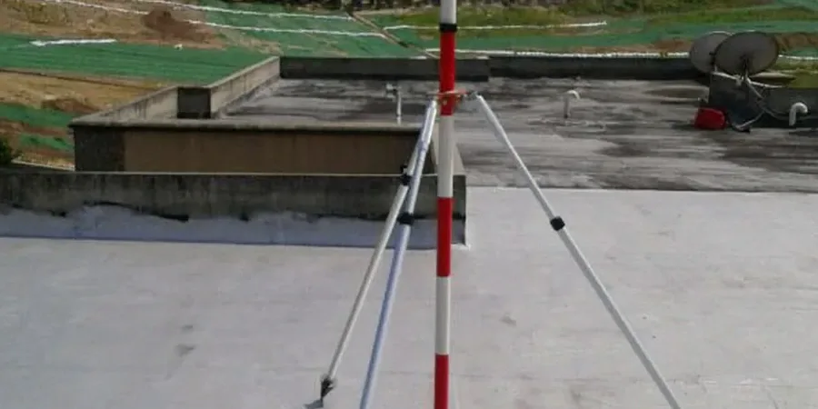
Automated Total Station Monitoring
Robotic total station networks with wireless prism arrays tracking X, Y, Z displacement of shoring walls, adjacent buildings, and utility bridge crossings at programmable intervals. Data is pushed to a secure portal with SMS and email alerts when movement exceeds 80% of design threshold values.
Inclinometer & Tiltmeter Arrays
In-place inclinometer strings grouted into boreholes behind soldier pile walls to capture the complete subsurface deformation profile. Paired with surface tiltmeters on adjacent structures to differentiate building rotation from foundation settlement.
Vibration & Crack Monitoring
Triaxial geophones and digital crack displacement gauges deployed on historically sensitive structures, including the unreinforced masonry buildings concentrated in Glendale’s Downtown Specific Plan area. Peak particle velocity and crack width trends are correlated with excavation and compaction activities.
Dewatering & Piezometric Monitoring
Vibrating wire piezometers and settlement extensometers installed around the excavation perimeter to quantify the zone of influence of dewatering operations, critical for complying with the Sustainable Groundwater Management Act requirements in the San Fernando Basin.
Common questions
What is the typical cost range for a geotechnical excavation monitoring program in Glendale?
Monitoring programs in Glendale generally range from US$770 to US$2,770, depending on the number of instrumentation points, the monitoring duration, and whether automated total stations or manual readings are specified. A basic setup with manual inclinometer readings and crack monitors on two adjacent buildings falls at the lower end, while a fully automated system with 30+ prisms, in-place inclinometers, piezometers, and real-time cloud reporting reaches the upper range. Each program is quoted based on the specific shoring design and the City of Glendale’s monitoring plan requirements.
How does Glendale’s proximity to the Verdugo Fault affect monitoring requirements?
The Verdugo Fault runs along the northeastern boundary of Glendale and is capable of producing a magnitude 6.7 event. Because the fault traverses the city limits, the Building & Safety division requires that monitoring plans for excavations deeper than 15 feet include a post-seismic inspection protocol. Our systems are configured to capture a high-frequency data burst immediately following any ground motion exceeding 0.1g, allowing the engineering team to assess whether the shoring system’s residual capacity remains adequate before workers re-enter the excavation.
Which monitoring instruments are required for excavations adjacent to unreinforced masonry buildings in downtown Glendale?
The City of Glendale’s geotechnical review guidelines specify that any excavation within a horizontal distance equal to the excavation depth from an unreinforced masonry (URM) structure must include continuous vibration monitoring with triaxial geophones and automated crack displacement gauges on all exterior wall faces. Peak particle velocity is typically limited to 0.25 in/sec for pre-1971 URM buildings. Additionally, settlement points must be installed at the building corners and at the midpoint of the wall facing the excavation, with readings taken daily during active earthwork and weekly thereafter until backfill is complete. More info.